Below are examples of the recent projects and applications we have provided in hydromorphology, geomorphology, habitat assessment, survey, training and decision support.
Projects
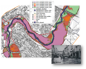 Floodplain boundary mapping using aerial photo interpretation and hydrogeomorphological surveys on 10kn of the river Avon near Chippenham (for more information click here).
- Investigation of the relationships between engineering pressures, morphology and species for the English and Scottish environment agencies. Production of the first map of channel substra
 te distribution across the entire river network along with other indices representing geomorphic activity, flow regime and vegetation structure using geospatial predictive models (link).
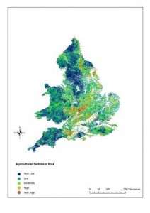
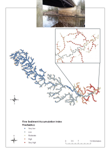
 - Development of a methodology for mapping the risk of agricultural sediment input on freshwater ecosystems in English and Welsh rivers using existing national survey data, predictive models and geostatistics. Production of maps of fine sediment distribution and agricultural sediment accumulation risk to ecosystems.
 Environmental Impact Assessment of a river diversion on flood risk and risk of failing WFD environmental targets on a Cumbrian river. Design of new river channel (link).
- Appraisal of options for relocating a gauging station on the river Eden.
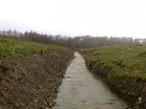
 Assessment of sediment accumulation problems at a gauging site on the river Nidd (Yorkshire). Identification of sediment sources and processes (link).
- Modelling habitat suitability using expert opinion and existing monitoring data, RHS, hydrology, water chemistry and land use data for 3 species of fish (trout, dace and pike) (Link).
- Data collation and statistical relationships between environmental pressures/engineering activities and fluvial forms, processes and invertebrate taxa as part of the development of an Artificial Intelligence decision support tool for the Environment Agency.
- Organisation of a workshop on the criteria for the evaluation of the ecological integrity of the trout zone with the French Electricité de France (EDF) R&D unit, the ONEMA (National Agency for Water and Aquatic Environments) and Cemagref (Agricultural and Environmental Engineering Research).
- Development of an ‘ecological vision’ for several Conservation Rivers (e.g. River Camel and tributaries SSSI, River Teme and Clun SSSI). A key element of this strategy is in development of an approach that incorporates assisted recovery to achieve river restoration at a large scale. Report to Natural England.
Decision Support
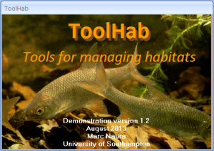
- Design and development of a Decision Support System (ToolHab) for prioritising sites for river restoration for the Environment Agency.
- Compilation of an evidence summary document on physical modification pressures impacting on the hydromorphology of water bodies for the Water Framework Directive.
- Development of an approach for assessing the potential impacts of proposed consents, licences and applications on hydromorphology as part of the Water Framework Directive implementation in England and Wales.
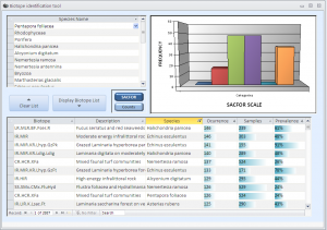
- Design and development of BioScribe, a software for matching species lists to known biological communities and biotopes (JNCC).
Expertise
- Provision of expertise to government organisations on geomorphology, ecology and River Basin Management. Member of the UK TAG Morphological Quality Element (MQE) sub-group, providing technical advice to regulators on the delivery of the WFD.
Surveys
- WFD assessment and pre-restoration monitoring of a Hampshire stream in the New Forest.
- WFD assessment of a small stream in Cumbria (link).
- Geomorphological appraisal of the Hampshire Avon catchment and identification of river restoration options.
- River Habitat Survey and geomorphological surveys of rivers potentially impacted by low flows and abstractions in South-East England.
Pingback: River Habitat Survey Toolbox software | River Habitat Survey
Pingback: NEW – River Habitat Survey Toolbox 32 and 64 bit software | River Habitat Survey