
Background
Here we present a series of selected applications of ToolHab and supporting elements towards Water Framework Directive (WFD) and hydro(geo)morphological issues. Three case studies were selected representing a range of data availability, model and index use (see morphological index application for more information).
Case study 1: Identifying the potential causes of GES failure on the River Aire (Yorkshire) in a data rich environment.
The river Aire between the towns of Skipton and Keighley fails its WFD status with regards to fish populations. As water quality has been improving consistently, it was felt that habitat may be limiting fish populations. The section of interest was surveyed in 1999 using River Habitat Survey (RHS).
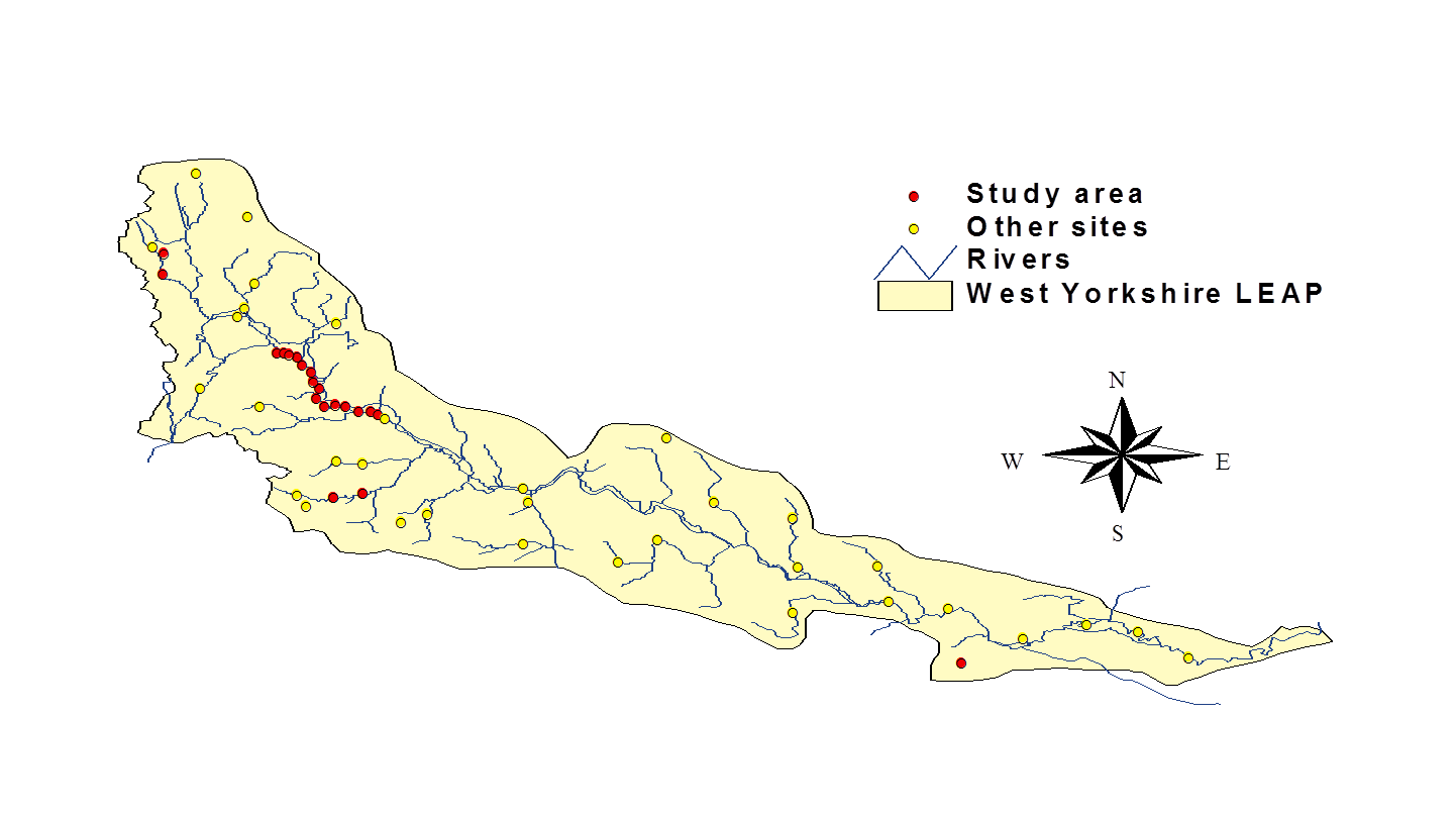
The river Aire originates from Malham Tarn in Yorkshire and flows through Skipton and Leeds before entering the use near Goole. The location of the 15 RHS sites is shown below.
 All RHS sites were grouped into a single reach in ToolHab. Using the FCS module in ToolHab, we found that the river reach had an overall low (i.e. Poor) fish EQR (see below). The right-hand and middle columns respectively display the probability of finding fish species at reference condition and the probability that numbers observed are below what can be expected at reference condition. Six species were observed, among them minnow, grayling, trout, bullhead, stoneloach and gudgeon. Stoneloach and minnows seemed to be in numbers greatly exceeding what can be expected at reference condition whereas the most likely species at reference condition (i.e. trout) was in low numbers.
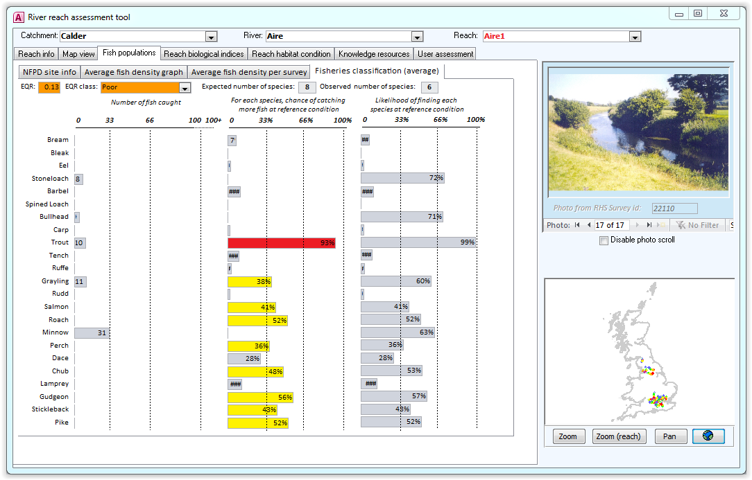
An investigation of fish density using ToolHab average fish density graphs (see below) confirmed the predominance of minnows and stoneloach and the relative absence of other species.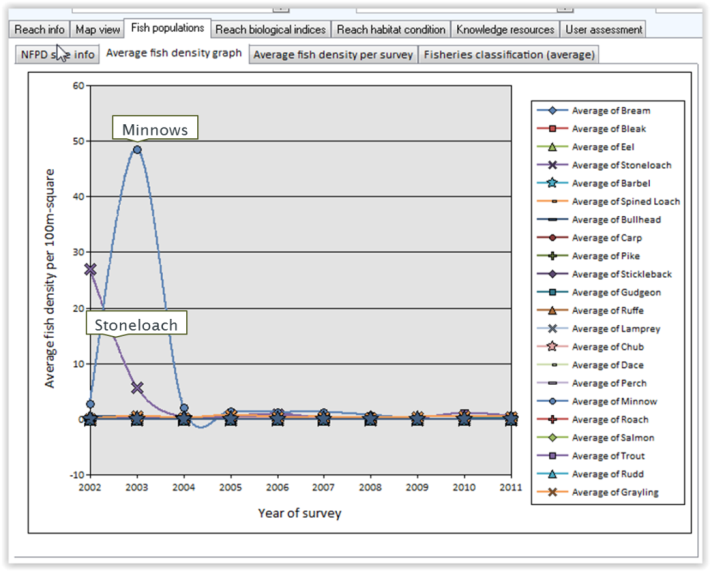 Using ToolHab summary statistics graph for biological indices (figure below), we investigated the presence of water quality issues from organic sources and potential impacts from low flows using BMWP, ASPT and LIFE scores from 1975 to 2009. BMWP and ASPT scores showed fair to good water quality levels whereas high Life scores indicated fast water velocities.
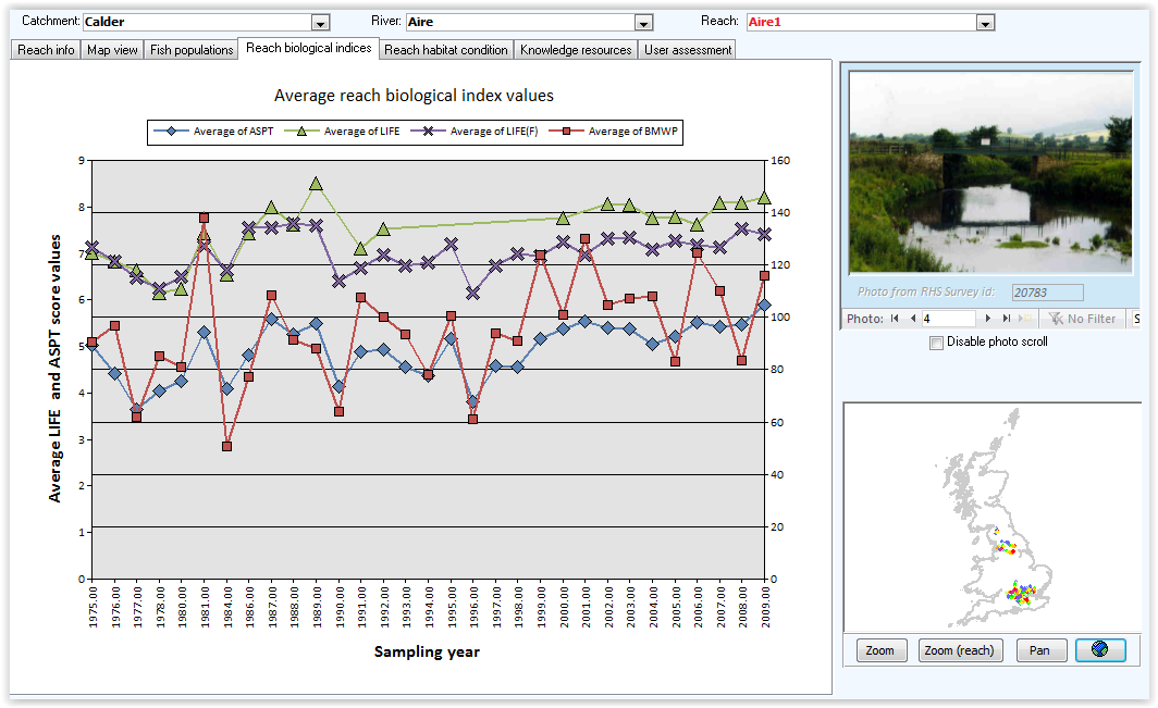
Water quality was further investigated in map view with specific reference to nitrates and phosphates. The river reach seemed to display very high concentrations of phosphates (1mg/l) and moderately low concentrations of nitrates (20mg/l).
 Summary statistics from the ‘Reach habitat condition’ module showed high levels of engineering pressures (see below). The main sources of modification were channel and bank resectioning, embankments, bridges and bank reinforcement.
Using available statistics on man-made structures, we found that 57% of the bank length had been resectioned and 44% had embankments.

Further investigation of hydromorphological features using habitat indices showed a dominance of gravel-pebble/sand substrate and glide habitats with some signs of activity (mainly bank erosion) and the predominance of emergent and submerged channel vegetation types (see below). Some riffles were observed but altogether the channel tended to be featureless.
We used the ‘Habitat assessment’ module in ToolHab to assess trout habitat and identify potential causes and effects leading to poor EQR. The ‘Habitat assessment’ module provides a graphical representation of expert driven Structural Equation Models for trout habitat. The middle section of the graph below displays habitat features normally associated with natural trout habitat such as coarse substrate, unbroken waves (i.e. riffles) the presence of cover and resting areas for adults. The boxes are coloured using the WFD colour scheme to show their overall suitability for trout. The section on the left displays all potential pressures on trout habitat coloured according to their overall impacts on fish density. The lines between the pressures and the habitat features show how impacts are mitigated. The model suggests that most habitat features associated with trout were missing or in poor condition. The main sources of impact were likely to be bank and channel resectioning and enrichment by phosphates.
The results from the analyses suggest that the reach below Skipton should have higher densities of trout at reference condition than observed. The data and models included in ToolHab point towards two potential sources of pressures: enrichment by phosphates and channel resectioning
Case study 2: Identifying the potential causes of GES failure on the River Petteril (Cumbria) in a data poor environment.
In 2009, the Environment Agency ran a pilot case study on the river Petteril in Cumbria to test various approaches towards identifying pressures and impacts and designing programmes of measures under the WFD. One cause of concern on the river Petteril was a failure in fish EQR linked to a gradual decline in trout populations. A range of issues from land use, water quality to hydromorphology were investigated. At the time, only six sites had been surveyed for RHS which was not enough to repeat the same analysis as in the previous case study. Instead, we used maps of hydromorphological indices, aerial photos, Google and OS first edition maps.
The river Petteril was split into reaches using hydromorphological index values and a spatial clustering algorithm. Average morphological index values were computed for each reach from source to mouth for observed and semi-natural predictions (see figure below). The graphs show a difference between observed and predicted semi-natural condition. Channel substrate was mainly composed of gravel-sand/silt and became coarser further downstream contrary to semi-natural predictions that followed a more traditional fining sequence from source to mouth with a gradual decrease in channel substrate size from cobbles to gravel-pebble. Similar discrepancies could be observed for the Flow Regime, Geomorphic Activity and Channel Vegetation indices along with a general lack of channel diversity.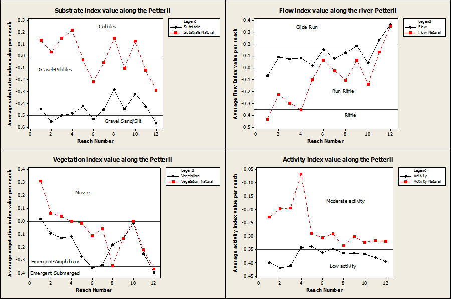
An investigation of potential causes using maps and aerial photo revealed straightened sections in the upper part of the river with relic and side channels still visible (see below).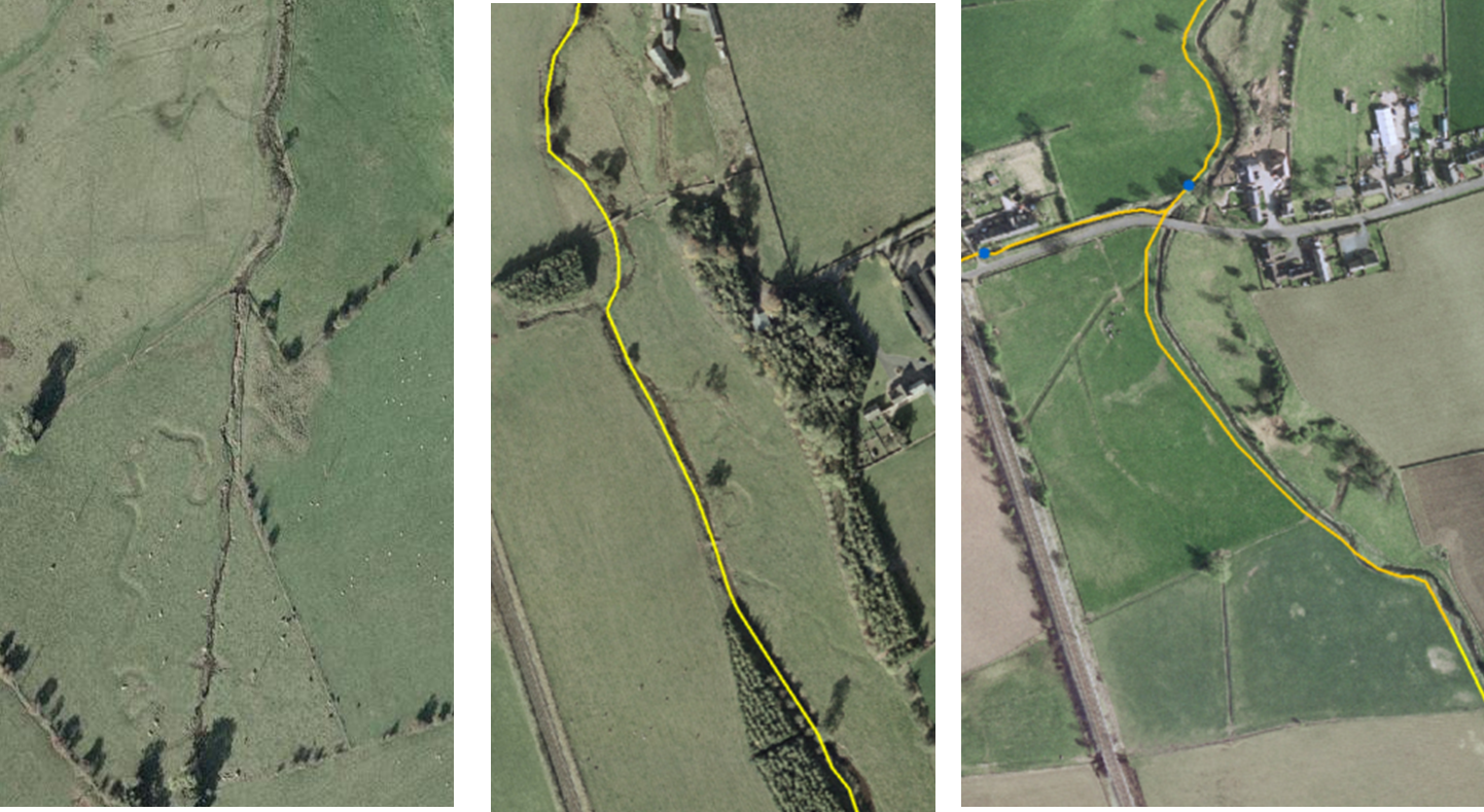
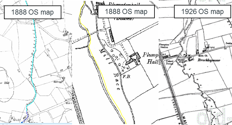
Using first edition OS maps we found that some of the modifications in the upper part of the catchment pre-dated the earliest recorded maps (1888 OS map; see below left and middle map) and were probably related to the presence of mills. Other modifications were more recent (right-hand map) and were potentially linked to nearby infrastructure (motorway and railway) or agricultural land.
 A walkover survey confirmed the presence of channel realignment and resectioning potentially responsible for habitat losses and changes in hydromorphological condition in parts of the catchment. We concluded that hydromorphological pressures, along with other potential factors such as water quality and water temperature, may be the cause of fish population decline over the past 50 years in the river Petteril.
Case study 3: Identifying the causes and sources of fine sediment accumulation on the lower river Nidd (Yorkshire).
The Environment Agency recently commissioned a study on the causes of fine sediment accumulation at a gauging station at Skip bridge at the downstream end of the river Nidd. A geomorphological analysis of fine sediment source, transport and accumulation was undertaken using ToolHab and maps of morphological indices produced by Riverdene Consultancy (see Morphological index application for more information).
The river Nidd is a regulated river whose course has been very stable for the past 160 years. The upper reaches are characterised by the presence of 3 large reservoirs built in the early 20th century. The river Nidd was intensively surveyed in 1996 with more than 120 back-to-back RHS from its mouth to 60 km upstream.
 This figure shows changes in channel substrate composition along the river Nidd using the CHannel Substrate Index (CSI). The Nidd can be split into three sections based on substrate composition. In the upper reaches, channel substrate is dominated by coble substrate, switching to gravel pebble in the middle reaches (60 km away from the source) to be dominated by sand and silt in the lower reaches (79 km from the source) before entering the Ouse. It is interesting to note that each switch in substrate dominance was correlated with the presence of major weirs: Goldsborough Farm weir (59km) and Mill Farm weir (79km) (see pictures below).
Is sediment size at Skip bridge natural? The predictions for semi-natural values of the Channel Substrate Index indicate that channel substrate at Skip bridge should be coarser (gravel-pebble) than observed.
Where does fine sediment come from? Maps of fine sediment delivery indicate that fine sediments mainly originates from agricultural run-off from upstream areas. Although bank erosion is present around Skip bridge, it is unlikely to be responsible for sediment accumulation. Gravel dominance seems to stop at Mill farm weir, 5km upstream of Skip bridge indicating a potential effect of the weir on coarse sediment transport.
Is sediment size is not natural, what may cause fine sediment accumulation? RHS Habitat Modification Scores (HMS) around Skip bridges indicate high levels of modifications with channel realignment, over-widening and over-deepening. Larger, deeper rivers will have slower velocity profiles and a reduced ability to transport sediment at high flows. Skip bridge is located near the Ouse junction and it is likely that during high flows, the water from the Ouse backs up creating a ‘backwater effect’. The combined impact of reduced coarse sediment supply, reduced flow velocities due to channelisation and backwater effect may explain the accumulation of fine sediment at Skip bridge.
Conclusion
The three applications demonstrate the potential use of ToolHab and elements of the hydromorphology toolbox towards solving real-world WFD-related sediment and species management issues. More generally, they demonstrate how tailored tools and indices packaged in a Decision Support Tool adapted to users’ needs can help solve problems in a cost-effective way and support local experts’ decision-making.
You must be logged in to post a comment.