Introduction
A Water Framework Directive (WFD) hydromorphological assessment of a Cumbrian river as part of a realignment scheme for a development project was performed using a River Habitat Survey combined with a hydromorphological visual assessment The unnamed river was surveyed from its confluence with the river Derwent to 500m upstream. The work was done in collaboration with The Environment Partnership.
Methodology
River Habitat Survey Habitat Modification (HMS) and Habitat Quality (HQA) Scores were calculated and the Habitat Modification and Habitat Quality Assessment classes were derived using standard Environment Agency methodology (Raven et al. 1997). The General Habitat Quality class was derived following using the Environment Agency methodology (Walker 2005). Flows and flood events, channel capacity, velocity profiles and shear stress were modeled using the FEH database, the Revitalised Flood Hydrograph (ReFH) model, Micro-drainage and the Conveyance Estimation System.
Results
The River Habitat Survey data analysis yielded the following results:
- Habitat Modification Score: 3220
- Habitat Modification Class: Severely Modified (class 5)
- Habitat Quality Assessment: 31
- Habitat Quality Assessment class: 4 (poor)
- General Habitat Quality class: Extremely Poor (class 5)
Figure 1: photo of the stream a) through the proposed scheme b) boulder ramp downstream of A66 culvert.
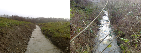 The river was extensively modified (figure 1a). It was realigned, overdeepened and resectioned with the presence of culverts and major structures. The river banks had been recently reprofiled at the time of survey. The river was artificially steep (24m/km) and deep and dominated by large pebbles, cobbles and fast flow features. There was no evidence of riffles and pools formation or any notable in-channel features. The land use was intensive with improved grassland dominant on both banks. The vegetation structure and both banks was mainly absent (bare) or reduced to short grass. There was no channel vegetation at the time of survey.
Because of overdeepening, the river was effectively separated from its floodplain. Modelling of Qmed flow over the existing cross-section showed that a one in two year flood event should reach a height of about 20 cm compared to an existing bank height of 1.6 m.
The Habitat Modification Score was extremely high (the lower limit for Habitat Modification Class five is 1400). This is due to the presence of culverts, resectioning and reinforcement. The Habitat Quality Assessment score was low compared to sites of similar types. The site score of 31 falls within the bottom 36% of sites of similar types in the 1995-1997 baseline survey. Using the 2007-2008 baseline survey, the site still falls within the bottom 30% of sites of similar type (HQA class 4). The RHQ, which combines HQA and HMS was ‘extremely poor’ reflecting the high level of modification combined with low habitat quality. Altogether, the site had very poor ecological value and displayed very high levels of hydromorphological impacts and very little channel diversity on habitat quality. Its hydromorphological quality was very poor.
Recommendations
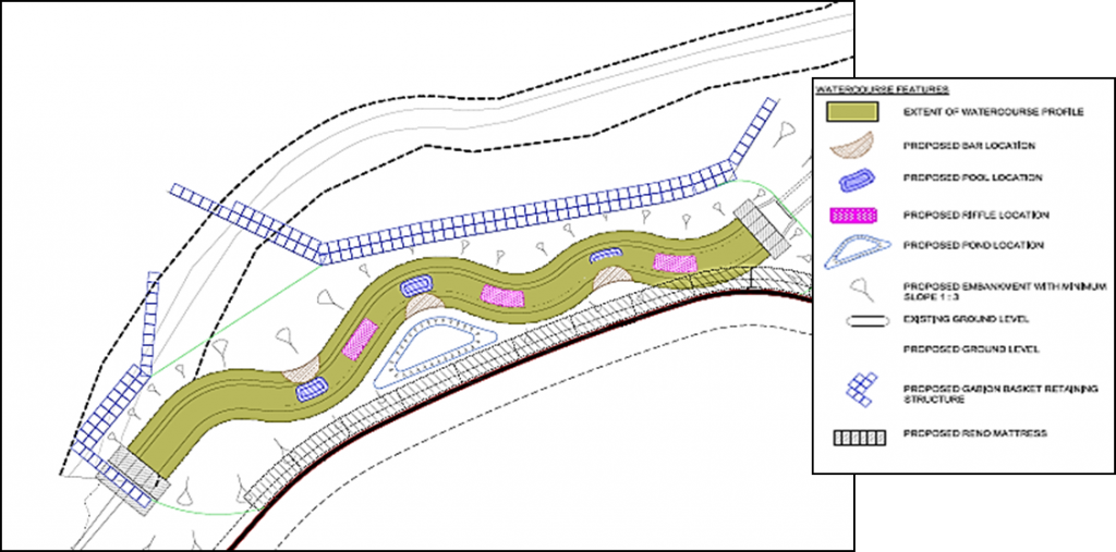
Based on this assessment, it was proposed to deal with some of the hydromorphological issues highlighted during the survey and find a compromise between the need to improve the hydromorphological condition of the stream and the need to protect structures from the risk of flooding or erosion. We proposed to reduce the steep slope artificially created by channel realignment so as to permit the reinstatement of naturally occurring riffle-pool sequence as opposed to the existing plane bed structure. The stream planform would be slightly re-meandered and riffles and pools along with point bars would be introduced at meander bends and on straighter sections. A two-stage channel structure would be created to re-introduce a more natural channel cross-section and re-establish lateral connectivity to a series of berms acting as surrogate floodplains and wetlands. The first stage of the channel would be designed to hold a one in two year flood events . The design of the channel was calculated so as to reproduce more natural processes whilst minimising the potential risks of erosion and flooding.
References
Raven, P.J., Fox, P., Everard, M., Holmes, N.T.H. & Dawson, F.H. (1997) River habitat survey: A new system for classifying rivers according to their habitat quality. Freshwater Quality: Defining the Indefinable?, 215-234.
Walker, J. (2005) River Habitat Objectives. Environment Agency, England and Wales.
You must be logged in to post a comment.