River Habitat Survey
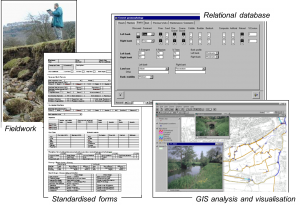
 We provide accredited RHS surveyors and trainers as well as data input and analysis. River Habitat Survey (RHS) is a standard methodology for recording geomorphological and habitat features on 500m river reaches. The method is compliant with CEN standards on hydromorphological assessment required for the Water Framework Directive (WFD) implementation. We have applied RHS to WFD assessments, geomorphological and ecological appraisal.
Geomorphological surveys and audits
 We conduct Catchment baseline Surveys and Fluvial Audits following standards by Sear et al. (2004). Data can be provided in a variety of format and turned into maps and analytical outputs. We also offer custom ad-hoc surveys on morphology, ecology and habitats for various purposes such as fine sediment source identification, WFD assessments, geomorphological assessment for hydropower schemes and river restoration.
Hydrogeomorphological surveys of flood risk boundaries
 The hydrogeomorphological cartographic method is a method for mapping alluvial floodplains using geomorphological surveys and aerial photography. We have experienced surveyors and aerial photo interpretors and we offer a full service from aerial photo interpretation to report production (see example).
Pre and post-project appraisal and monitoring
 We design and perform surveys for monitoring the impacts of river restoration and river management schemes (e.g. capital schemes). Surveys are designed according to the schemes objectives and the potential level of impact expected. Survey may include detailed measurements of channel dimensions, floodplain mapping using aerial photos or land scanner, sediment sizing, mesohabitat mapping and channel vegetation surveys.
Biological surveys
With our partners, we provide detailed biological surveys of river macrophytes, fish and biological elements using standard sampling methodologies and techniques.

You must be logged in to post a comment.