
River Habitat Survey Toolbox
Desktop software for River Habitat Survey (RHS) and Citizen RHS. Enter or import your surveys, check their quality, calculate habitat indices, compare sites with the national baseline, and estimate River Condition Assessment (RCA) scores for Biodiversity Net Gain.
Windows 8–11 · Microsoft Access 2013 or later, or the free Access runtime · 32-bit and 64-bit
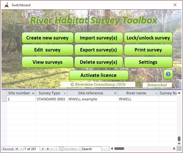
Built for RHS surveyors, consultants and river managers
The RHS Toolbox takes you from field form to analysis in one place. It checks your data for errors and missing values, calculates the standard RHS indices and newer hydromorphological indices, and puts your site in context against sites of similar type from the national reference network.
It has been used for Water Framework Directive assessments, planning applications, habitat and restoration assessments, and is now being used for river condition assessment for Biodiversity Net Gain.
What’s new in version 2.2
A major update, developed with the support of Natural Resources Wales and in collaboration with the River Restoration Centre.
River Condition Assessment (RCA)
Estimate the RCA condition score and class (Poor to Good) for any RHS site in your database, using the method behind river condition in the Statutory Biodiversity Metric for Biodiversity Net Gain.
Citizen River Habitat Survey
Data input form, quality control and indices for Citizen RHS (cRHS), plus a review-and-upgrade workflow that turns a cRHS into a full RHS.
Share data online
Publish RHS and cRHS surveys to the online RHS/cRHS platform with georeferenced photos, videos and 360° photos, which become a virtual walk with a summary report on the map.
Data analysis tab and report
A plain-language summary of index values and what they mean, flags for likely modifications such as resectioning, and links to RRC restoration techniques and case studies. Included in the survey printout.
Improved context analysis
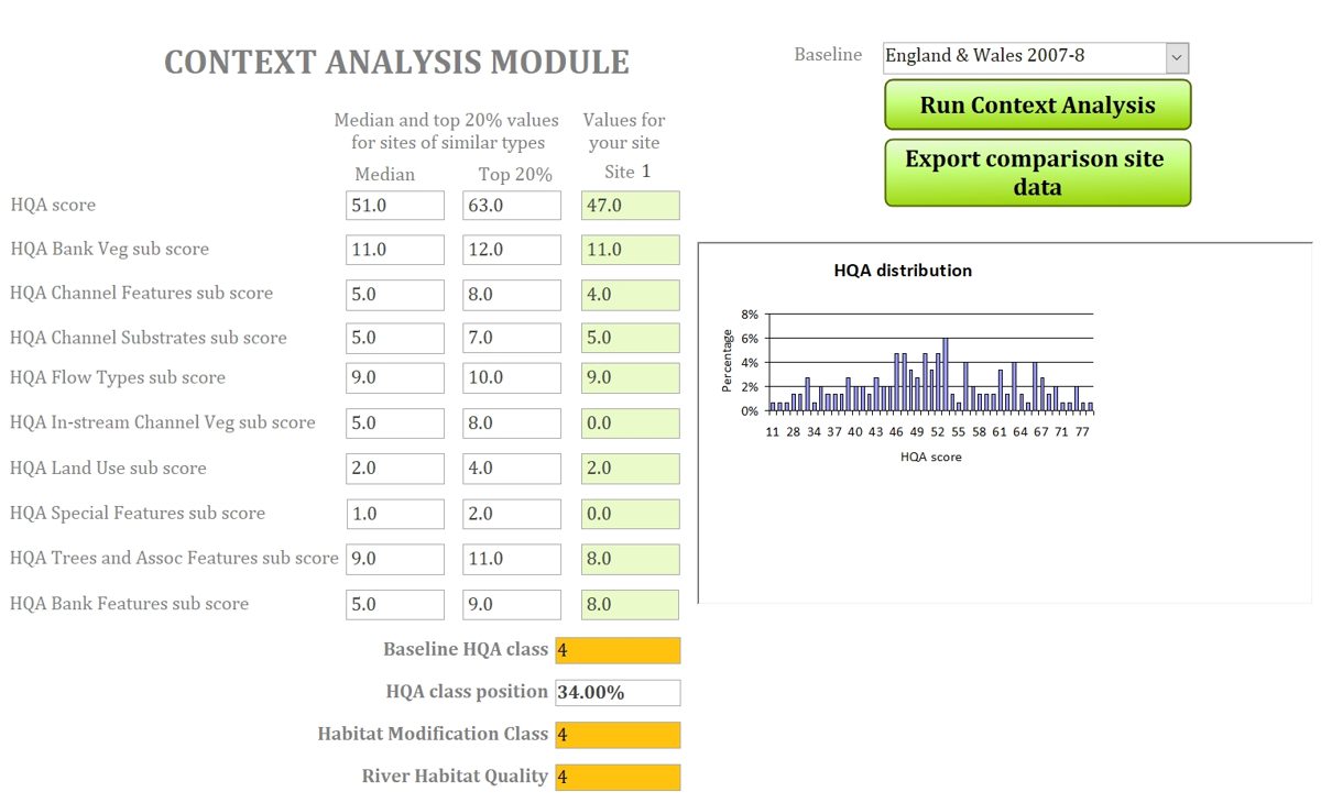
Compare your site’s HQA score and sub-scores with the top 20% of sites of similar type, as well as with the full comparison sample.
New indices
Width/depth ratio, Channel Resectioning Index, and bank and riparian vegetation naturalness for RHS with Phase 1 surveys.
River Condition Assessment from RHS data
The RCA (Gurnell et al., 2020) scores the physical condition of a river reach against what is expected for that river type in a near-natural state. It was designed for MoRPh surveys. The Toolbox applies the same river typology, indicators and published thresholds to your RHS records:
- River type: desk-study and bed-material indicators (A1–A8) are suggested from map data and the survey, then the RCA decision tree gives a preliminary type you can accept or change.
- All 32 condition indicators for bank top, bank face, channel margin and channel bed are calculated from the RHS spot-checks and sweep-up.
- Preliminary Condition Score and Final Condition Class, including the adjustment for over-deepened channels.
- You stay in control: values you enter are never overwritten, your choices are flagged, and each calculation is logged with a date.
RCA results from the Toolbox are RHS-based estimates, not a replacement for a MoRPh survey. They let you look at river condition across existing RHS datasets and compare it with HQA, HMS, RHQ and other indices. Check the current Statutory Biodiversity Metric User Guide for the survey methods accepted in a BNG submission.
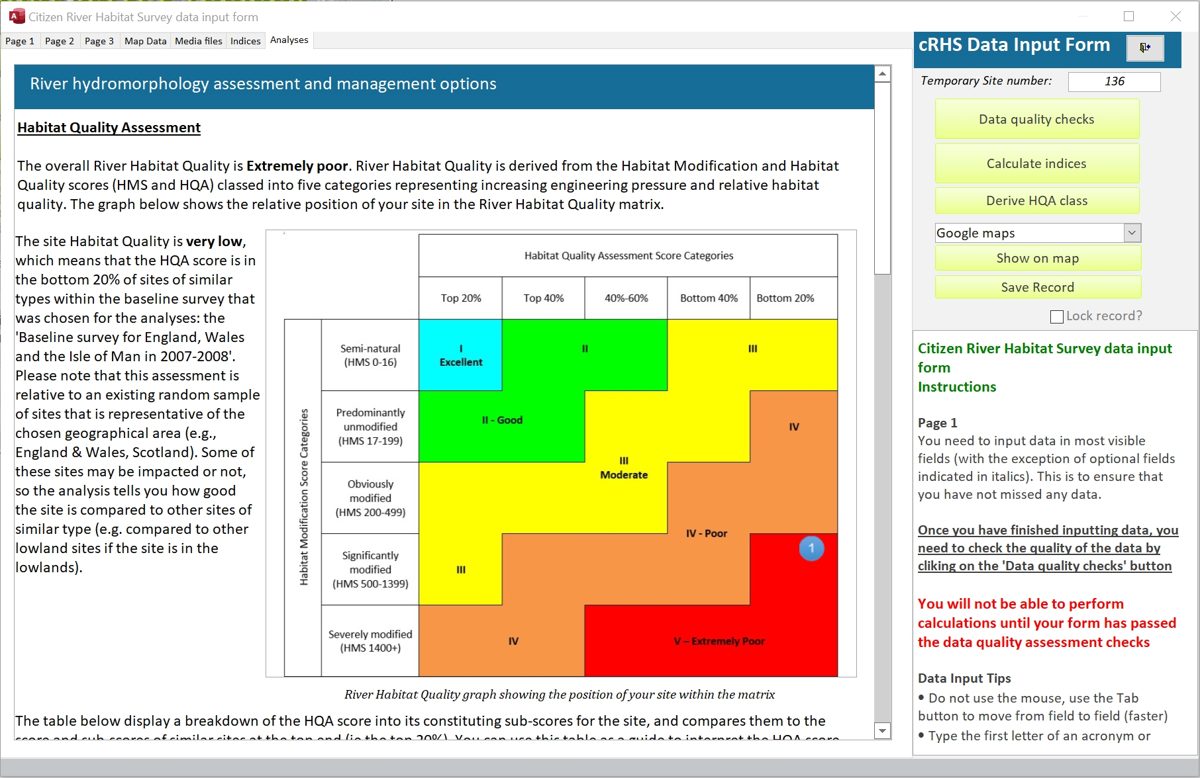
Everything you need for RHS data
Data entry
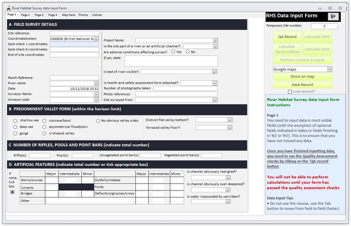
- Standard RHS 2003, Mediterranean 2003 and Phase 1 2003 formats
- Citizen RHS form
- Optional RHAT (Northern Ireland) scoring sheet
- UK and Irish grid references or WGS84, with automatic conversion
- Photos, videos and 360° photos linked to each survey
Quality control
- Checks for missing and inconsistent data
- Logic checks across the form
- An information window guides you through each page
- Lock surveys to prevent accidental edits
Indices
- Habitat Quality Assessment (HQA) and Habitat Modification Score (HMS), with sub-scores
- River Habitat Quality (RHQ) and Riparian Quality Index (RQI)
- Hydromorphological indices (CSI, FRI, CVI, GAI) and Impact Ratios (HIR)
- Agricultural fine sediment indices (ASL, FSA, ASR)
- Stream power, shear stress and width/depth ratio
- River Condition Assessment
Context analysis and map data
- Automatic extraction of altitude, slope, distance from source and other map data for sites in England, Wales and Scotland
- Jeffers PCA scores and HQA class against sites of similar type
- Comparison with the top 20% of similar sites
- View your site on current and historical maps
Import
- RHS Mobile and Citizen RHS Mobile Android apps, with photos
- RAPID versions 2 and 3
- cRHS surveys from the online database for upgrade
Export and print
- Excel workbook, PDF, HTML, RTF and text
- Export of comparison-site data for further analysis
- Upload to the online RHS/cRHS platform
- Print complete RHS forms and reports
- Shared network database (site licence)
Free trial and licensed use
Every feature (except uploading to the online database) is available free for 30 days. After the trial you can keep entering, importing and checking data, but the analysis features need a licence.
| Feature | After trial, no licence | Licensed |
|---|---|---|
| Enter and edit RHS and cRHS surveys | ✓ | ✓ |
| Import from the RHS Mobile apps | ✓ | ✓ |
| Quality control | ✓ | ✓ |
| Calculate indices, including RCA | ✗ | ✓ |
| Extract map data | ✗ | ✓ |
| Context analysis | ✗ | ✓ |
| Export to Excel and other formats | ✗ | ✓ |
| Export to and import from the online RHS/cRHS platform | ✗ | ✓ |
| Shared network database | ✗ | Site licence |
Licence options
All licences are yearly subscriptions. Prices are in GBP.
Individual licences: one user, activated on your PC
Business & public sector
- Consultancies, government agencies and local authorities
- All licensed features
Charity, not-for-profit & self-employed
- Registered charities, Rivers Trusts, not-for-profit organisations and sole traders
- All licensed features
Student
- Students using the Toolbox for their studies
- All licensed features
Charity, self-employed and student licences are discounted. We may ask you to confirm eligibility using the organisation details you give at checkout. Need an invoice or a purchase order? Email info@riverdeneconsultancy.com.
How buying and activating works
- Install the trial
Download and install the Toolbox. Everything works for 30 days. - Buy a licence
Choose your licence above and pay securely online by card through Stripe. - Get your key
Your activation key is emailed to you after payment. - Activate
Open the Toolbox, click Activate licence on the switchboard, enter the key and click OK.
Your subscription renews each year. Your survey data are stored on your own computer, and you can still enter, import and check surveys if you don’t renew.
Download
Which version do I need?
Choose the version that matches your Microsoft Office: 32-bit or 64-bit. To check, open Word and go to File › Account › About Word; the first line ends with 32-bit or 64-bit. If you don’t have Office, choose 64-bit.
Windows may warn that the installer is unrecognised. This is because of the software’s certificate; choose to keep and run it.
System requirements
- Windows 8, 10 or 11
- Microsoft Access 2013 or later, or the free Microsoft Access runtime
- The installer checks for and offers to install the Access runtime, Microsoft Visual C++ 2017 Runtime and MySQL Connector/ODBC 8.0 if they are missing
- Install on a local drive, not a USB key or network drive
- Internet connection for map data extraction, updates and online sharing
RHSDataInput_be.accdb (note the _be) from your existing RHS Toolbox folder to a safe place. After installing version 2.221, copy it back into the new application folder, replacing the existing file. Version 1 and version 2 can be installed side by side.
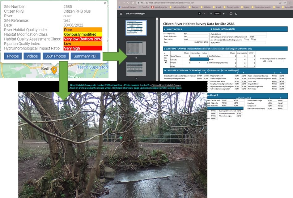
Works with the RHS Mobile apps and the online platform
Record surveys in the field on an Android phone or tablet with the RHS Mobile or Citizen RHS Mobile apps, with GPS positions and geotagged photos. Import them straight into the Toolbox for quality control and analysis.
When you’re ready, publish surveys to the online RHS/cRHS platform hosted by the River Restoration Centre, where they appear on a shared map with photos, videos, 360° virtual tours and a summary report.
Frequently asked questions
Do I need Microsoft Access?
No. If Access isn’t installed, the installer downloads and installs the free Microsoft Access runtime for you.
Can the RCA results be used for a Biodiversity Net Gain submission?
The Toolbox gives RHS-based estimates of the RCA using the published indicators, typology and thresholds. They are not a substitute for a MoRPh survey. Check the current Statutory Biodiversity Metric User Guide for the survey methods accepted for BNG.
Can several people share the same data?
Yes, with a site licence (business or charity; email us for details). Each person installs the Toolbox on their own PC and the shared data file is placed on a network drive. WebDAV drives are not supported, and the application itself should not be run from a server.
Does the Toolbox work outside the UK?
Yes. You can enter, check and analyse surveys anywhere using WGS84 coordinates, and the Irish grid is supported. Automatic map data extraction, context analysis predictions and some indices currently cover Great Britain only.
I’ve changed computer. How do I move my licence?
Email info@riverdeneconsultancy.com and we’ll help you transfer it. Remember to copy your RHSDataInput_be.accdb data file to the new computer.
Where can I get help?
Press F1 in the Toolbox to open the help file, or email info@riverdeneconsultancy.com to report a bug or suggest an improvement.
Developed with partners
Version 2 of the RHS Toolbox was developed with the support of Natural Resources Wales and in collaboration with the River Restoration Centre. The Toolbox implements methods published in the peer-reviewed literature, including the RHS habitat indices (Raven et al., 1998; Walker, 2005), hydromorphological indices (Naura et al., 2016) and the River Condition Assessment (Gurnell et al., 2020).
Questions, training or bespoke analysis? Contact info@riverdeneconsultancy.com.